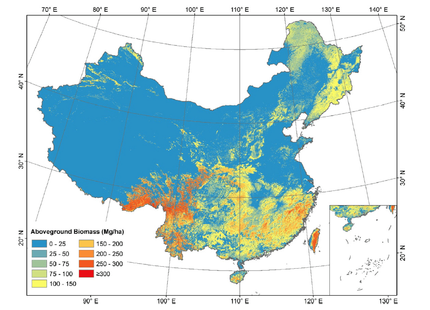
The global forest ecosystem, which acts as a large carbon sink, plays an important role in modeling the global carbon balance. An accurate estimation of the total forest carbon stock in the above ground biomass (AGB) is therefore necessary to improve our understanding of carbon dynamics, especially against the background of global climate change. In this project, we developed a new method to map wall-to-wall forest AGB distribution through the combination of ground inventory data, Geoscience Laser Altimeter System (GLAS)/Ice, Cloud, and Land Elevation Satellite (ICESat) data, optical imagery, climate surfaces, and topographic data. Over 8000 ground inventory data was collected to address this mission. Our nationwide wall-to-wall forest AGB mapping results show a good correspondence with independent ground inventory evaluation dataset. The coefficient of determination (R2) and root-mean-square error between our predicted results and the validation dataset were 0.75 and 42.39 Mg/ha, respectively. This new method and the resulting nationwide wall-to-wall AGB map will help to improve the accuracy of carbon dynamic predictions in China.
Reference
Su, Y., Guo, Q., Xue, B., Hu, T., Alvarez, O., Tao, S., & Fang, J. 2016. Spatial distribution of forest aboveground biomass in China: Estimation through combination of spaceborne lidar, optical imagery, and forest inventory data. Remote Sensing of Environment, 173, 187-199