Global forest ecosystems form a large carbon pool, and are a critical component of the global carbon cycle. Accurate estimations of global forest aboveground biomass (AGB) will improve understanding of global carbon dynamics and help quantify anthropogenic carbon emissions. In this study, we mapped the global forest AGB density at a 1-km resolution through the integration of ground inventory data, optical imagery, Geoscience Laser Altimeter System/Ice, Cloud, and Land Elevation Satellite data, climate surfaces, and topographic data. Our globally continuous or wall-to-wall forest AGB map showed that the global forest AGB density was 210.09 Mg/ha on average, with a standard deviation of 109.31 Mg/ha.
Reference: Hu, T., Su, Y., Xue, B., Liu, J., Zhao, X., Fang, J., Guo, Q. * 2016. Mapping global forest aboveground biomass with spaceborne LiDAR, optical imagery, and forest inventory data. Remote Sensing. 8(7): 565.
(2) Global mangrove forest AGB map in 2004
Mangrove forest ecosystems play an important role in carbon cycles and biodiversity. Accurately mapping global mangrove aboveground biomass (AGB) will help us understand how mangrove ecosystems are affected by the impacts of climatic change and human activities. In this study, we produced a global mangrove forest AGB map for 2004 at a 250-m resolution by combining ground inventory data, spaceborne LiDAR, optical imagery, climate surfaces, and topographic data with random forest, a machine learning method. From the published literature and free-access datasets of mangrove biomass, we selected 342 surface observations to train and validate the mangrove AGB estimation model. Our global mangrove AGB map showed that average global mangrove AGB density was 115.23 Mg/ha, with a standard deviation of 48.89 Mg/ha.
Reference: Hu, T.; Zhang, Y.; Su, Y.; Zheng, Y.; Lin, G.; Guo, Q*. Mapping the Global Mangrove Forest Aboveground Biomass Using Multisource Remote Sensing Data. Remote Sensing. 2020, 12, 1690.
(3) Global forest woody residence time in 2004
Woody residence time is an important parameter that expresses the balance between mature forest recruitment/growth and mortality. Using field data collected from the literature, our group explored the global forest τw and investigated its influence on model simulations of aboveground biomass (AGB) at a global scale. We estimated the global 1 km τw using a random forest method by integrating the field based data, precipitation, Gross Primary Productivity, temperature, DEM and evapotranspiration as predictors. The estimated forest τwwas averaged 66.7 years globally with large spatial heterogeneity. The estimation of τw can help improve the model simulations and reduce the parameter’s uncertainty over the projection of future AGB in the current DGVM or Earth System Models.
Reference: Xue, B., Guo, Q. *, Hu, T., Xiao, J., Yang, Y., Wang, G, Tao, S., Su, Y., Liu, J. and Zhao, X. Global patterns of woody residence time and its influence on model simulation of aboveground biomass. Global Biogeochemical Cycles.31(5): 821-835.
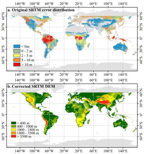
(4)Corrected SRTM DEM
SRTM (shuttle radar topography mission) DEM (digital elevation model) is a near-global terrain product with high accuracy, and has been widely used in many researches. However, it has been proved that SRTM DEM is systematic higher than the real ground truth in vegetation regions, as the absorption and reflection of radar signal from leaves and trunks of vegetation, and terrain conditions. To reduce the SRTM systematic bias in vegetated areas, we collected over 150, 000 km2 airborne LiDAR data to develop a new globally corrected SRTM DEM. 1) The SRTM DEM error models depending on canopy height data, canopy cover data and land cover data were built over various vegetation types. 2) The linear regression based method was used to estimate the original SRTM DEM error and therefore correct the SRTM DEM data.
Notes: The CSRTM file with an extension of “_corrected.tif” are corrected topographic data. The other SRTM data are not corrected as they are not covered by vegetation.
Reference: Zhao Xiaoqian, Su Yanjun, Hu Tianyu, Chen Linhai, Gao Shang, Wang Rui, Jin Shichao, Guo Qinghua*. 2018. A Global Corrected SRTM DEM Product for Vegetated Areas. Remote Sensing Letters. 9(4): 393-402.