The Digital Ecosystem Group discovered and precisely measured the Tibetan cypress, the tallest tree in Asia (102.3 m) and the second tallest tree species in the world. The team also counted the number of trees in China and mapped their distribution across the country. These findings have been featured in a series of high-profile international media outlets, including Live Science, Global Times, China Daily, and others.
Media Coverage: Digital Ecosystem Group Featured in CCTV’s National Ecological Progress Report
On August 12, 2025, the Digital Ecosystem Group was featured in a key news report on CCTV titled “Perceiving Ecological Change,” which highlighted China’s leadership as the world’s fastest and largest contributor to global greening. The full report is available at: https://tv.cctv.com/2025/08/12/VIDEFOvO4gjETKSYyti7T0IG250812.shtml. The coverage focused on the group’s field investigation of giant tree communities in the Yarlung Zangbo Grand Canyon, Xizang, using LiDAR technology.
Media Coverage: Prof. Qinghua Guo’s Interview Featured on CCTV’s “Voice”
On August 9, 2025, Prof. Qinghua Guo was invited to CCTV’s renowned program “Voice” (开讲啦), where he shared his team’s long-standing research in forest ecology and remote sensing technology. The full interview is available at http://tv.cctv.com/2025/08/09/VIDEr20Wl6okBovl4DYMDEYl250809.shtml.
During the program, Prof. Guo detailed team’s work on developing China’s first high-resolution tree density distribution map and exploring the Asia’s tallest trees. By combining professional expertise with vivid storytelling, he made ecological science accessible to the public.
Media Coverage: Research Achievements of the Digital Ecosystem Group Featured by BBC Wildlife
On February 28, 2025, the research findings from the Digital Ecosystem Group were featured in BBC Wildlife (Discover Wildlife), with the full report available at https://www.discoverwildlife.com/plant-facts/trees/how-many-trees-are-there-in-china. This pioneering study, published in Science Bulletin, delivers the most detailed assessment of tree abundance and spatial distribution across China to date, achieved by integrating over 400 terabytes of data from 76,000 forest plots with environmental factors and advanced machine-learning algorithms.

GeoAI Research
GeoAI research Our team is dedicated to frontier research in Geospatial Intelligence (Geo-AI), building a comprehensive technical framework centered on spatiotemporal foundation models. By integrating multi-source heterogeneous data—including point clouds, imagery, and text—we have overcome critical bottlenecks in cross-modal alignment and spatiotemporal big data mining. We focus on developing AI-driven perception algorithms and structural modeling […]
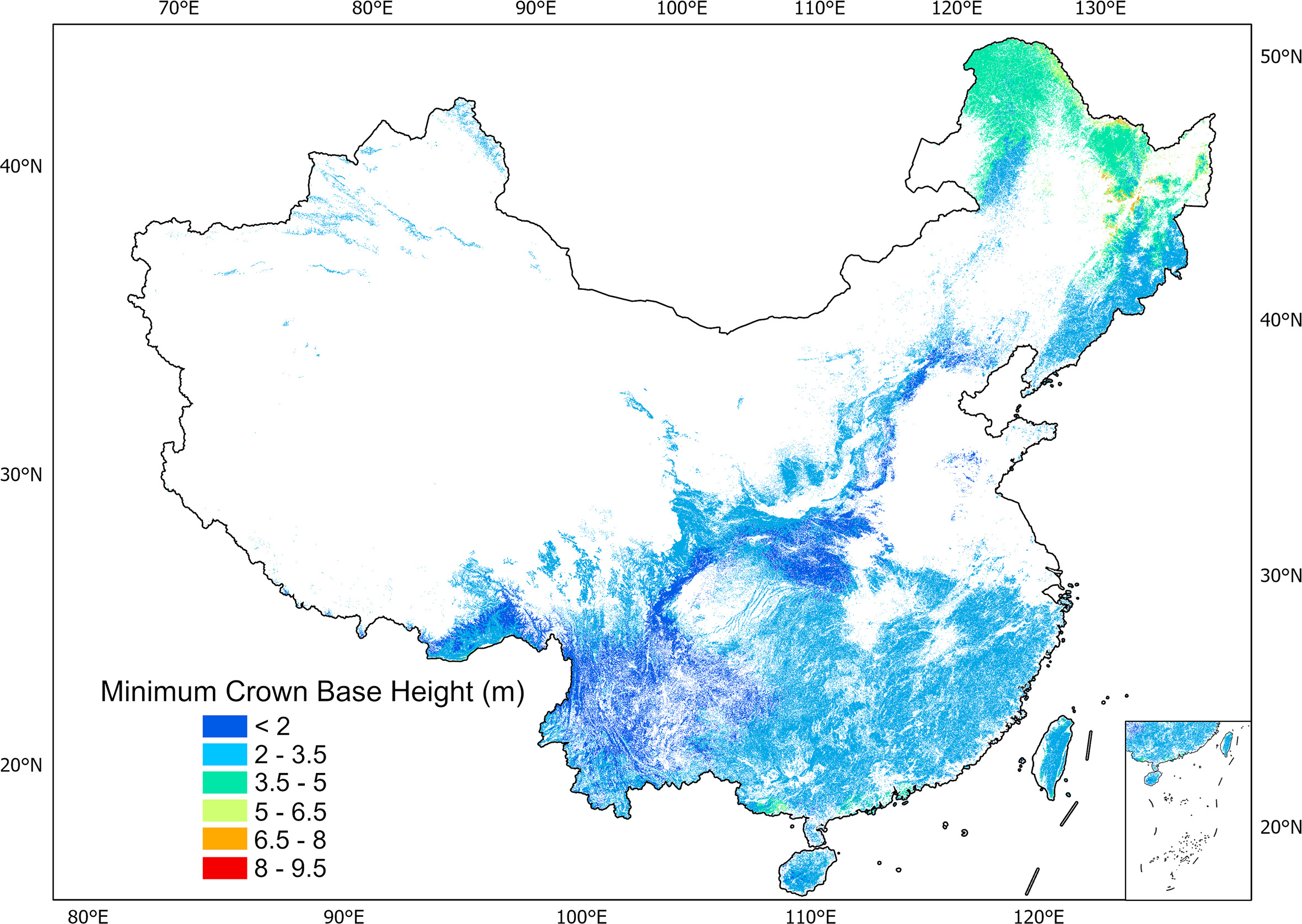
China forest crown base height
Correction: Data uploaded before May 8, 2026 may contain errors in minimum crown base height values (CBHmin) . Please re-download the latest version. Crown base height (CBH) is essential for characterizing forest vertical structure over time for sustainable forest management and serves as a key input in fire model and growth model. At plot level, […]
Spatial Intelligence & Geo-Foundation Models
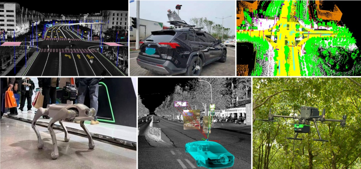
Spatial Intelligence & Geo-Foundation Models Our research group focuses on the core domains of Spatial Intelligent Perception and Autonomous Navigation, driven by the frontier of Geospatial Intelligence (GeoAI). We integrate cutting-edge technologies including LiDAR SLAM, photogrammetry, and multi-source information fusion, with a strategic emphasis on Geospatial Foundation Models. To meet the operational requirements of mobile […]
Global vegetation products-draft
Global Vegetation Products (1) Global forest AGB map in 2004 Global forest ecosystems form a large carbon pool, and are a critical component of the global carbon cycle. Accurate estimations of global forest aboveground biomass (AGB) will improve understanding of global carbon dynamics and help quantify anthropogenic carbon emissions. In this study, we mapped the […]
Regionl vegetation products
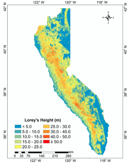
Regional Vegetation Products Forests tree height across the Sierra Nevada Forests of the Sierra Nevada (SN) mountain range are valuable natural heritages for the region and the country, and tree height is an important forest structure parameter for understanding the SN forest ecosystem. There is still a need in the accurate estimation of wall-to-wall SN […]

Sample data for the book “LiDAR Data Processing Methods -A LiDAR360 Software Tutorial (in Chinese)”
This book systematically explains the principles of LiDAR technology and, using the LiDAR360 software platform as an example, provides detailed instructions on LiDAR point cloud data processing and its applications in various fields. It is divided into three parts and comprises fifteen chapters. The first part, Chapter 1, provides an overview of LiDAR technology, its […]